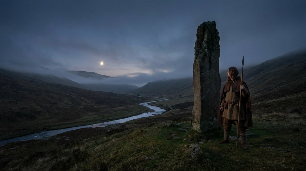

The sleepy coastal town of Burghead becomes the focus of an ancient pagan ritual on the 11th January every year. As the Clavie, a barrel of burning tar is placed on the altar at the Doorie Hill the Brochers (natives of Burghead) watch on. The wood crackles. Sparks rise into the night skies. The flames dance and are reflected in the revellers’ eyes. Why are they doing this? The origins of this fire festival have long faded but the current Brochers know that it was important to their forebears. Perhaps it is that connection to our ancestors and to tradition that gives Brochers a sense of their identity and helps them to know their place in today’s world.
Burghead: A Place of Mystery
Burghead is a place of mystery. The Doorie Hill is on the fringes of an ancient Pictish Promontory Fort. It is a huge complex, the biggest in Scotland. Alas, much of the site is now buried due to a ‘modernisation’ scheme which took place in the 1800s. Obviously, this fort was a significant site in its heyday, but it was never mentioned in any of the writings of its time. To add to the mystery, there is an ancient well on the site which looks like it might have been used for some kind of ritualised practice. Nobody knows who built the well or why. And what about the carved bulls? Several carved stones with bulls incised on them have been recovered from the site. They are definitely Pictish in style but they are not your normal symbol stones.
Further down the coast, to the east, lie the caves at Covesea. Here great collections of human bones have been gathered and reverenced. Meanwhile, Pictish symbols have been carved into the walls at the entrance to one of the caves. This was once a sacred site and for a long time, it held a dark secret. The cave was used for ritual killings.
Burghead Past and Present
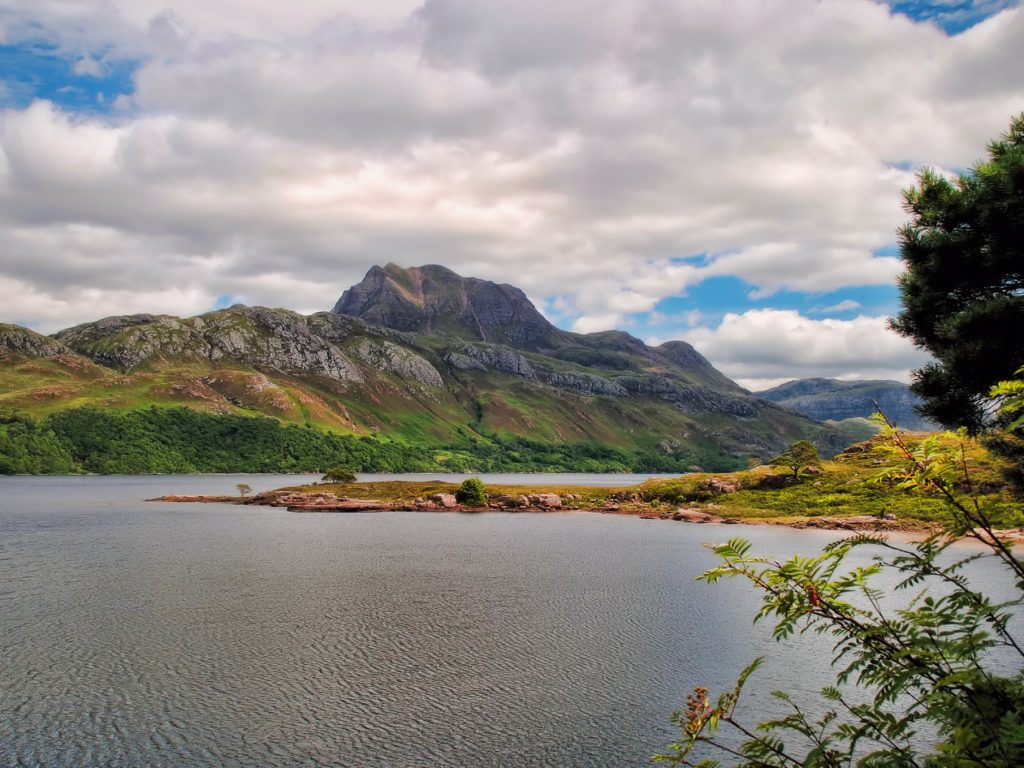
Burghead Promontory Fort is located on a headland that juts into the Moray Firth. Today an old Coastguard Lookout sits on top of the fort site. It has been converted into a heritage museum. From the top of the lookout site, the wind off the sea feels raw and bitter cold. Yet the views are stunning. Across the water, the smoky silhouettes of the Highland beinns dominate the horizon. To the south, lies the town itself. From a defensive point of view, the site is perfect. You can see for miles.
However, the landscape around Burghead has changed dramatically from when the Picts occupied the fort. A sea loch, known as Loch of Roseisle once cut into the land on the west side of Burghead. The sounding hinterland comprised of boggy and marshy land which stretched between the Loch of Roseisle and a further sea loch to the east, Loch Spynie. This in effect made the headland almost an island. The caves at Covesea would also have been joined to this near-island piece of land. Loch Spynie still exists today in a smaller form and is now completely landlocked. This site obviously was carefully chosen as a defensive site on which to build the fort.
Today Burghead is marketed as a Pictish capital by the tourist industry. The presence of the ancient monument coupled with the ancient Burning of the Clavie tradition signals that Burghead was once an important powerbase in Scotland’s early history.
Burning the Clavie
On the 11th of January every year, people brave the sub-zero temperatures to take part in the 1,600-year tradition of Burning the Clavie. Burghead is a cold place at the best of times, far less in the height of winter.
Traditionally, the Clavie was made from herring barrels but is now made from a whisky barrel cut down to 17 inches. (Small wonder, given that Burghead is located in the county with the highest concentration of distilleries in the world!) The Clavie is filled with tar and staves of wood. It is nailed onto a pole with a specially forged nail. It has been suggested that the word clavie may be derived from the Gaelic cliabh, a basket for carrying combustibles, though others propose the Latin clavus meaning a nail since the nail used to fix the barrel to its carrying post is traditionally re-used from year to year.
The Clavie Procession
The procession begins with the Clavie King setting light to the fire. His role is to ensure that the traditional rituals are adhered to. He is supported by a group of around fifteen men, who form the Clavie Crew. To carry the Clavie you must be a born and bred Brocher. The tough Clavie crew take turns of carrying the burning cask, dripping with tar along a route down Granary Street following the outline of the ancient Burghead settlement. They stop from time to time, giving faggots to certain residents as a ‘lucky’ piece of the Clavie. Meanwhile, the smoke and flames from the Clavie are said to be warding off evil spirits.
At the end of the procession, the Clavie is put into a stone altar upon the Doorie Hill, the site of the last remaining section of the Pictish fort. This is where the fire really gets going. Accompanied by cheers, more and more staves are thrown into the inferno along with tar. Eventually, the barrel collapses and the gathered crowds scramble to get their hands on the embers which were once said to have provided charms against witchcraft. Traditionally the embers would have been taken home and used to kindle the New Year’s Fire. The charcoal is then gathered and placed into the Brochers’ chimneys to prevent spirits and witches from emerging from under the mantelpiece.
Celebrating the Old Scottish New Year
The burning of the Clavie on the 11th of January stems from the introduction of the Gregorian calendar in the year 1600. This meant that 1599 was a short year. A huge outcry ensued, triggering public disorder in some villages. But the canny Brochers, saw this as an opportunity to celebrate New Year twice per year.
Origins of the Burning of the Clavie
The origins of the burning of the Clavie have long been lost in the mists of time. However, modern clavie burning does offer some interesting historical insights. The direction of the Clavie procession, clockwise or sunwise, through the streets, hints at the same fundamentally solar nature typical of midwinter fire festivals globally. Was this ritualistic fire festival created by the Picts in the old fort out of their simple fear that the sun would not be reborn, and that light and fertility would not return to the land? Or perhaps it was to celebrate the turning of the Wheel of the Year. It may even have its origins in the practices of the Viking raiders who would later camp on the fort site.
However, gathering the embers is suggestive of neid fires which were burnt at the four Gaelic Quarter Days of Samhain, Imbolc, Beltane and Lughnasadh, where the hearth fire in every home would be doused and relit from the communal bonfires. Fire was the lifeblood of every home, providing heat, food and a place where the family could gather and tell tales through the long winter nights. The relighting of the fire from a communal source indicates the importance of the fire in bonding the whole community together.
Some Interesting Thoughts about the Burning of the Clavie
There are parallels between the Burning of the Clavie and the Fire Ball procession at Stonehaven. Both celebrate the coming of the New Year. Both sites have a Pictish connection. Although Stonehaven is not directly built over a Pictish Promontory Fort, it is built near one. The sea stack of Dunnicaer lies between Stonehaven and Dunnottar.
Interestingly, the Presbyterian establishment damned the Burning of the Clavie as “idolatrous, sinfule and heathenish” and officially banned it in 1704. However, the tradition persisted. Now each year large numbers of visitors join the inhabitants of Burghead to celebrate the ‘old’ Scottish New Year.
Who were the Picts?
From the Fourth Century AD Roman writers referred to the predominant people in Northern Scotland as the ‘Picti’, meaning the ‘Painted Ones’ in Latin. These shadowy people from the frontiers of time were regarded as savage warriors by the classical authors. However, by the time the Vikings swept into Scottish waters, the Picts had faded into the merest of memories, their culture engulfed as they merged with their Celtic brothers, the Gaels. They left no written records. Yet the amazingly intricate carved stones and silver work they left behind show that they were not the unsophisticated barbarians the Romans implied they were.
Just because there are no written records does not mean that they could not write but at the time of the Gaelic takeover, the main historians were monks and clerics. The Celtic church was deeply influenced by Gaelic culture and perhaps those writing the annals of the time thought that the former Pictish works were irrelevant. Alas, with the disappearance of their writings, the Pictish language was lost forever, the only fragments being found in place names. Because of this, we have no clear insight into how they lived, their society or what their belief system was before the coming of Christianity. The anecdotal evidence we are left with is deeply flawed and biased.
The Origins of the Picts
In an ancient Irish Gaelic rhyme, we read:
“Moirsheiser do Cruithne clainn,
Raindset Albain i secht raind,
Cait, Ce, Cirig, cethach clan,
Fib, Fidach, Fotla, Fortrenn.”
This roughly translates as:
“Seven sons of Cruithne then,
Into seven divided Alba,
Cait, Ce, Cirig, a warlike clan,
Fib, Fidach, Fotla and Fortrenn.”
We now know that this a mythical account of the origins of the Picts although the Pictish Kingdom was indeed split up into several federations, each with their own king. It is now generally accepted that the Picts were not, as was once believed, a new race, but were simply the descendants of the indigenous Iron Age people of northern Scotland.
What does Pict Mean?
In keeping with this, it is thought that the Pictish people spoke a form of Brythonic, the language of the Britons or original inhabitants of Britain. The Welsh language today has evolved from this ancient tongue. We do not know what the Picts called themselves. The word “Pict” means “painted people”, and probably was derived from the Pictish custom of either tattooing their bodies or embellishing themselves with “warpaint”.
However, the Irish name for the Picts was “Cruithni”, meaning “the people of the designs”, paralleling the Roman name, so it may be that “Picti” was an adaptation of the name they called themselves. The elements “Pett” and “Pitt” are certainly a common feature of placenames in Pictish territories. The Norse invaders, when they arrived in Orkney, certainly described the inhabitants at “Pettr”.
The rise of the Picts was to play an important role in the development of the Ancient Kingdom of Alba or Scotland as we know it today. The Picts took part in one of the most decisive battles in Scottish history –the Battle of Dun Nechtain (Dunnichen). Had the Picts lost, Scotland might never have existed. Instead, it would have become an enclave of the Angles of Northumbria and would have become part of ‘Angleland’, later to become England.
Burghead Promontory Fort
It was thought that the Promontory Fort at Burghead began as an Iron Age fortification. Perhaps it was occupied by the Verturiones, the tribe which may have been the forebears of the Burghead Picts. During the early fifth century, as the Roman occupation of Southern Britain collapsed, the Burghead Picts acquired the wealth, resources, and the need to expand the Fort. Perhaps the need grew from the power vacuum created as the occupiers deserted their posts on Hadrian’s wall or maybe it was a response to the arrival a new threat: The Angles. Perhaps the Pictish navy had grown to the point where new moorings were needed.
Over the following centuries what evolved was the largest promontory fort in Scotland. It covered an area of 3 hectares or 7.5 acres, making it three times the size of any other centre of power in early Scotland.
Structure of the Burghead Fort
The fortress was composed of two distinct areas. The higher upper enclosure is thought to have been a royal or religious space and the lower area contained the settlement. Each enclosure was protected by huge ramparts. These walls were some 8 metres thick and 6 meters high. They were made of an oak framework held together with 20 cm iron spikes and filled in with rubble. This was then faced with sandstone. A timber breastwork would then have topped the structure. Both enclosures had their own entrances with no gateway between them, indicating a hierarchy between the two areas. However, the landward side of the overall enclosure was further defended by an additional three ramparts and ditches. A large harbour was built on the north-west side of the promontory, outside the annexe but still within the protection of the triple ramparts.
Recent excavations have uncovered a longhouse. This is an important find as relatively little is known about Pictish architecture. This building had a lovely stone-built hearth at one end. Among the finds of the dig was an Anglo-Saxon coin of Alfred the Great. This is indicative of a group of people who had established long-distance trade-routes.
Fortrui
For a long time Burghead was thought to have been a Roman camp- after all the Fort seemed too sophisticated to be built by a group of people written off by the Romans as semi-naked barbarians. Later speculation put Burghead as a Danish camp built by the Vikings. Recent work has revealed that the Fort was constructed during the Pictish era. However, this has left another question, which tribe of the Pictish confederation was based at Burghead. Recent research has challenged long-held assumptions and brought a renewed interest in Pictish history.
It was long held that the main Pictish powerbases lay in Central Scotland. The Fortrui is the most cited and most powerful Pictish kingdom. Once it was believed that it was located in Strathearn in Perthshire. In an unprecedented piece of work, historian Alex Woolf challenged the general consensus and stated that the River Findhorn or Findern, as it was once known as, also passed through a Strathearn, far from Scotland’s central belt. This shifting of the Fortrui hinterlands shed new light on some of the events in Pictish history. The placing made more sense for Columba’s visit to King Bridei at Craig Phadraig, the Fort outside Inverness. It placed the Battle of Dun Necthan in the Cairngorms. It was one of those lightbulb moments.
If the Fortrui were based in Moray, then it seems likely that Burghead was their capital. There is no other fort in the vicinity with the size and splendour of Burghead. It also had the harbourage for a Pictish navy.
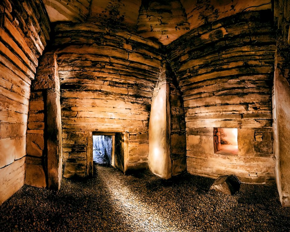
The Burghead Well
In 1809 Burghead offered up another enigma in the form of a ‘Roman Well’ During the clearance operations on the headland, it was noted that there was a shortage of water for the village. A local man remembered that there had once been a well within the lower enclosure. Sure enough, when the rubble was removed, the steps of the well were uncovered. The presence of a Roman coin and a wine jug was used as evidence to ‘prove’ that this was Roman. We now know otherwise.
William Young, the landowner at this time refers to the well being in ‘the centre of an enormous pile of tumbled-down walls … Among these ruins were many bones … Walls crop up all round the area of the bath or well …’
A Celtic head was said to be among the artefacts discovered there but its whereabouts are no longer known. The well is rock-hewn and consists of a flight of stairs which lead to a chamber. Within this, is sunk a cistern fed by springs. It is the only well of its kind in Scotland.
A Pagan or a Christian Well?
However, there is evidence that this well was not used for drawing water and bears some ceremonial importance. It has been suggested that this might be an early Christian baptistery. As the Picts embraced the Christian faith an ecclesiastical settlement was built within the Fort compound, dedicated to Saint Aethan. All that remains is a small graveyard. Remnants of carved Pictish stones have been found in the graveyard. However, although most early Christian baptisteries were often built outside a church, normally they were located to the west of the building. The Burghead well is located to the east and it was located too far away from the churchyard to be readily accessible.
It seems likely that it was a Pictish cult centre and possibly a place of ritual execution. Ritual killings by the Pict were fairly common. We know from history that the Picts drowned Talorgen, son of the King of Athol in 739 AD.
It should be remembered that Burghead has two wells and the Burghead well should not be confused with Saint Aethan’s Well which is located on the coastal path between Burghead and Hopeman.
The Burghead Bulls
It seems that some thirty carved panels were found at the site during the demolition work of the early 19th Century. These were finely inscribed with the image of a bull. However, only six panels now survive: one in the British Museum of London; one in the National Museum in Edinburgh; two in Elgin Museum and two in the Burghead museum. The rest, it seems, were built into the quay. Although each bull is unique, they are all very similar in size and design. They are all walking left to right. Although bulls have been incised on other Pictish symbol stones, this particular design is unique to Burghead. It is thought that the bulls are indicative of a Pictish pagan bull cult.
The bulls have been identified as 5th Century or later and it has been suggested that they formed part of a frieze set into the ramparts. This makes them completely novel as most Pictish Symbol stones are marker stones or parts of sarcophagi.
Clarkly Hill
On the lee side of the ridge overlooking Burghead, lies the remains of two different settlements. The first is a settlement of roundhouses, possibly starting in the late Bronze Age and certainly occupied in the Roman Iron Age when the inhabitants had privileged access to valued Roman goods. One of the roundhouses shows an interesting sequence of events where it seems that standing stones were erected into the roundhouse ditch. It is likely that the house was turned into a monument or a ceremonial centre.
Superimposed on the original settlement, is a more fragmentary settlement of stone buildings. Cobbled stone platforms are thought to have supported buildings. Their dating is still uncertain, they are medieval at latest, and maybe Pictish.
Iron smelting at Clarkly Hill
A geophysical survey carried out at Clarkly Hill has revealed a magnetic anomaly towards the northern edge of the site. During excavations, a series of charcoal-rich soil packed full of iron-working slag was recovered. Quantities of bog ore were also recovered.
During the iron age and early medieval periods, bog ore was the main source of iron ore. It was found close to the surface in wetlands and marshes making it easily accessible. However, this was dirty and back-breaking work. Those hunting the iron ore would look for an oily slick, indicating the presence of the ore. They would then probe the area with a staff looking for rocky clumps. One of the advantages of utilising bog iron is that it is sustainable. The ore is produced by bacteria and it only takes 25 years for the ore to replenish itself. The bog ore was probably extracted from the margins of the former Loch of Roseisle. Clarkly Hill was situated on a terrace above the loch.
In addition to the evidence of iron smelting, there is evidence of bronze casting notably fragments of crucibles. It appears that this was an area of intensive activity. Given the scale, it seems likely that this was a major site with skilled craftsmen. Is it significant that the settlement was located close to the fort?
Sculptor’s Cave
About 6 km to the east of the promontory fort lies a cave system which holds one of Moray’s darkest secrets. One of the caves at Covesea is named Sculptor’s Cave after the enigmatic Pictish symbols carved at its entrance. This place was not easily accessible either by land or sea. It can only be approached at low tide. The fact that it was used for centuries despite its lack of access, indicates that this was once a place of extreme importance.
This was a dark and frightening place, situated between land and sea and between the upper world and the underworld. This was a liminal place, a place of ritual: a temple cave dedicated to dead children. From the bronze age onwards, it seems that this temple was the final resting place of the mummified bones of dead children. Their heads were adorned with golden hair rings. The children themselves would have been seen as liminal beings capable of importuning the gods or perhaps more importantly the goddesses of the time.
Decapitated Victims
Time passed. People continued to visit the caves, to cook, drink and eat within its walls. In Cave 2 there is evidence of crucible fragments, slag, ironwork and a possible furnace. Then in Roman Iron Age times, things take a sinister twist. Six decapitated bodies lie on the floor of the cave. The isotopes recovered from the bodies show that they belonged to the local indigenous population. These were not Roman soldiers.
Given the inaccessibility to the cave and its association with the dead, it seems that the decapitations took place here to be sanctioned by the underworld gods, spirits or ancestors. This was a time when many Iron Age Tribes formed confederacies in the face of Roman expansionism. Ultimately this was to give rise to the Picts. It seems that in the years prior to the fortification of Burghead there was some competition between the emerging elites of the area. Could the decapitations at Sculptor’s Cave represent politically motivated killings as factional conflicts erupted during the third century and later, as competing groups jostled for power? Were the victors of the power struggle using the cave’s liminal background as a means of justifying their claim to the territory. Were they the ancestors of the Burghead Fortrui Kings?
Burghead Home to the Fortrui Kings
There is no doubt that Burghead was once a significant place in the Pictish world. Today it is generally accepted that Burghead was once the Royal seat of Pictish Fortrui or Moray. There is no documentary or archaeological evidence to support this- only its remarkable size and lack of a comparable another Pictish site. It has been proposed that this was once the centre of a Pagan bull cult. Could the well have been a pagan drowning pool? It has been proposed that this was once a Pictish naval base and is thought to be one of the earliest Pictish power centres.
We do not know what the Picts called the fort. There is a thirteenth-century elaboration of the legend of Columba which refers to a magical cloak possessed by his mother, which shadowed the land from east to west, from Innis-mod (Inishymoe, Co. Mayo) to Caer-nam-Brocc. It has been argued that Caer-nam-Brocc is Burghead.
It is not until the Vikings arrive that we have a written name for Burghead.
The Vikings at Burghead
There is evidence that a huge fire in the ninth century led to the demise of the site. The same fire which spelt the death knell for the fort was the very means of preserving its remains in the present. The oaken framework was turned to charcoal as the flames engulfed the citadel. And the perpetrators of this heinous act? This was the age of the Vikings. It is believed that Burghead might be the Torridun which was captured by Sigurd the Mighty, Norse earl of Orkney in 884 AD. After pillaging the fort, it seems that it was rebuilt by the Vikings who named it Brughe.
It was to become their powerbase in Moray, leaving the Vikings and the Maormars of Moray at odds with each other. This was a time of treachery which is ably demonstrated by the tale of Maelbrigte the Tooth. The Norse were defeated by the Scots in 1010 AD and the fort fell into ruin. In time it would become known as Burghe-head.
Please feel free to share the spooky by using the links below .